Saturday, July 26, 2014

Hungry Mother State Park

Hungry Mother State Park is a jewel in the crown of the first six Virginia State Parks built by the Civilian Conservation Corp (CCC's) between 1933 and 1941.  The six park Virginia State Park system was dedicated in 1936 by Governor George Peery and State Park Director R. E. Burson at Hungry Mother State Park at an event attended by 5,000 people.  The land was donated by local landowners led by John D. and Mildred Lincoln who alone donated 1,881 acres on Hungry Mother Creek.


The CCC's created a 108 acre lake by building a dam on Hungry Mother Creek.  Hungry Mother offers a beach with bathhouse, boats, fishing pier, campgrounds, cabins, gift shop, visitor center, a six-bedroom family lodge that sleeps 15, hiking and biking trails, and restaurant. 

Click on my photos below to see them in high resolution on Flickr.  You can view the photos in high resolution by clicking here!


Legend has it that when the Native Americans destroyed several settlements on the New River south of the park, Molly Marley and her small child were among the survivors taken to the raiders’ base north of the park. They eventually escaped, wandering through the wilderness eating berries. Molly finally collapsed, and her child wandered down a creek until the child found help. The only words the child could utter were "Hungry Mother." The search party arrived at the foot of the mountain where Molly collapsed to find the child's mother dead. Today that mountain is Molly’s Knob, and the stream is Hungry Mother Creek.

https://flic.kr/p/obAqYw
female Mallard and her ducklings


Hungry Mother Lake - South End


Kayaker on Hungry Mother Lake


Lake View from Lake Trail Loop


Canoeing on Hungry Mother Lake


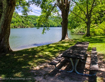
Lake Side Picnic Table


Hungry Mother Beach


Wild Rose along Lake Trail Loop


The Beach Scene


Summer Fun


Hungry Mother Beach from North End


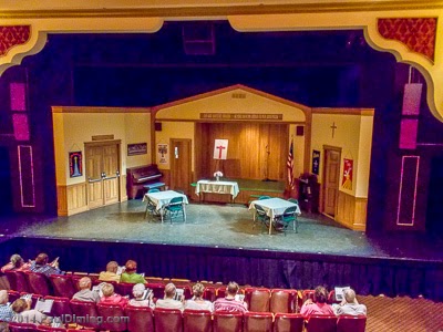
Hemlock Haven is now part of Hungry Mother State Park.  Hemlock Haven previously was a retreat center for Episcopal Diocese of Virginia from 1957 until 1989 when the Virginia Department of Conservation and Recreation purchased the property.  The facilities are now operated as the Hemlock Haven Conference Center.


You can view the entire set in high resolution by clicking here!


Tuesday, July 22, 2014

Abingdon Afternoon

On Thursday, July 3rd, we headed to Abingdon.  Abingdon is a town in Southwest Virginia with a population of 8,191 in 1910.  The town is the county seat of Washington County and is home to the Barter Theatre, Martha Washington Hotel & Spa, an end point of the Virginia Creeper Trail as well as a well known arts and crafts scene.

We left Hungry Mother State Park at 10:30 am and arrived in Abingdon at 11:20 am.  Our first stop was the Holston Mountain Artisans gallery on Park Street.  Very nice gallery with a variety of arts and crafts by over 100 local artists.  Well worth a visit!  

It was then time for lunch at Figaredo's Bistro at the corner of Main and Court streets.  We both enjoyed the cold Cucumber Soup.  Awesome!  Pam had the Garden Frittata while I had the Sausage Frittata.  Quite nice with a cold beer 8^)  

Click on my photos below to see them in high resolution on Flickr.  You can view the photos in high resolution by clicking here!


After lunch, we took a stroll through the area, cameras in hand.  Several historic properties are nearby.  First, The Tavern Restaurant located on Main Street.  Built in 1779, it is the oldest building in Abingdon.  It served as a stagecoach inn and tavern for travelers.  Their website claims the following visitors: Henry Clay; Louis Philippe, King of France; President Andrew Jackson; and Pierre Charles L'Enfant.  The building also housed the first post office west of the Blue Ridge.

The Tavern Restaurant c 1779

Across Main Street is "The Bank", home of the Exchange Bank of Virginia.  It was built in 1849 to house the bank as well as the cashier and his family.  After the American Civil War, the building was acquired by James Preston and has remained the residence of subsequent generations of his family.  For an interesting history about "The Bank" check out this website for the wedding of Mary Katherine & Ray.

The Bank c 1849


The Washington County Circuit Court building was built in 1868 during Reconstruction to replace the previous courthouse burned during the Civil War.  The courthouse features a large Tiffany stained glass window honoring the men and women who would serve in World War I.


The window was commissioned by the Washington County Board of Supervisors in July, 1918 to honor those from Washington County who have and would be serving in World War I.  By the end of the war, over 70 service men and women from Washington County lost their lives in the war.  The stained glass window is the center window on the second floor in the photo below.


The  beautiful stained glass window is inscribed with the words: “To the men and women of Washington County who answered the call of duty in the way of right and liberty.”

Tiffany stained glass window honoring those who served in World War I


The Barter Theatre was founded by Robert Porterfield in 1933 during the Great Depression.  The price of admission was 35 cents or the equivalent in produce.  Today, over 160,000 visit the theater located near the intersection of Main and Partington Place.  Playwrights at the theater included Noel Coward, Tennessee Williams an Thornton Wilder.

Barter theater was the first theater to be designated a "state theater", the State Theater of Virginia.  Gregory Peck, Patricia Neal, Ernest Borgnine, Hume Cronyn and Ned Beatty started acting there. 


We just had to see a play at the Barter Theatre so we chose a matinee on Thursday called "Welcome Back To Ivy Gap." 


Barter Theatre Main Stage seats 500


I remember staying at the Martha Washington Hotel & Spa in the 1970's.  It was built in 1832 at a cost of under $15,000 as a private residence for General Francis Preston, Sarah Buchanan Preston and their family of nine children.  It is located on Main Street near the Barter Theatre.  In 1858, it became the Martha Washington College for young women.  It operated for 70 years, through the Civil War and the Great Depression.  During the Civil War, students became nurses and the hotel grounds were used as barracks for the Washington Mounted Rifles.  

After the Civil War, the building housed Barter Theatre actors and actresses.  In 1935, it was opened as an inn. Since then, many famous guests stayed there including Eleanor Roosevelt, President Harry Truman, Lady Bird Johnson, Jimmy Carter, and Elizabeth Taylor.  In 1984, it was significantly renovated.


Not too far from the Martha Washington Inn is the Fields-Penn House on the corner of Main and Cummings Streets.  The mansion was built by James Fields in 1860 for his family.  Financial problems after the Civil War led to the sale of the house to George Edward Penn from Danville, VA.  Today, the home is open for visitors to explore and appreciate.


As we were walking to the Barter Theatre, we stumbled on this colorful wolf!  What is this wolf doing there?  A search on the net revealed that this wolf and many others are part of a fundraising campaign for Abingdon Main Street.  


One of the colorful Abingdon Main Street Wolves

You can view the entire set in high resolution by clicking here!

Saturday, July 19, 2014

Whitetop Mountain

At 5,520 ft high, Whitetop Mountain is Virginia's second highest mountain.  It is located at the juncture of Grayson, Smyth and Washington Counties.  The highest auto road in Virginia, FS89 (Mud Creek Lane) runs from VA SR 600 (Whitetop Road) to the summit of Whitetop.  The Appalachian Trail also crosses the summit of Whitetop Mountain.


On clear days, one can see three states.  From 1932-1939 Whitetop summit was the home of the Whitetop Folk Festival.

Click on my photos below to see them in high resolution on Flickr.  You can view the photos in high resolution by clicking here!

View of Buzzards Rock from the summit of Whitetop Mountain.


View from the summit of Whitetop Mountain


FS 89 (Mudcreek Ln) climbs the mountain from VA SR 600


Old Park Road area from Whitetop Mountain


Whitetop Mountain is a bald, covered with grass and conifers more typical of northern highlands such as spruce and firs.


Smaller of two radio/microwave towers on Whitetop summit

You can view the entire set in high resolution by clicking here!


Friday, July 18, 2014

Elk Garden Trailhead


Our fourth day in Southwest Virginia took on a loop through the Mt. Rogers National Recreation Area (NRA).  Our first stop was a picnic lunch at Grindstone Recreation Area.  We found picnic tables near a wading pool, fed by a cool mountain stream.  Pam enjoyed cooling her feet in the pool.

Click on my photos below to see them in high resolution on Flickr.  You can view the photos in high resolution by clicking here!


Cooling her feet in the wading pool @ Grindstone Recreation Area

After leaving Grindstone, we drove up to Elk Garden Trailhead.  At 4,450 ft, the open fields of Elk Garden lie in a gap between Virginia's two highest peaks: Whitetop at 5,518 ft and Mt. Rogers at 5,728 ft.  Two trails cross Whitetop Road (VA SR 600): the Appalachian Trail and the Virginia Highlands Horse Trail.


Appalachian Trail @ Elk Garden Trailhead


Appalachian Trail Blaze @ Elk Garden Trailhead


Virginia Highlands Horse Trail @ Elk Garden Trailhead


Fields of Elk Garden Trailhead


View from Elk Garden Trailhead

You can view the entire set in high resolution by clicking here!


Wednesday, July 2, 2014

Burke's Garden

I first heard of Burke's Garden from my Computer Science & Math professor at Radford College back in the 1970's.  Only now have I taken the opportunity to visit the area.  What a gorgeous place!  Burke's Garden is a natural bowl not formed by volcanic activity  Rather, it was formed by the erosion of the sandstone in the middle leaving harder rock of the rim.

If you go, I highly recommend you gas up and visit restrooms in Tazewell.  There is nothing much in Burke's Garden.  We were lucky to find the Burke's Garden General Store open when we happened by. I recommend you stop there.  Lots of great items for sale. 

The Lost World Ranch raises Appaloosa Llamas in Burke's Garden.  To get there, take a left on SR 666.  Don't you just love that "666" name?  If Burke's Garden is God's Country, why do they have a road called "666?"  

Do take the time to do the full loop of the bowl to see as much as possible.  When done, do take the SR 623 out of the bowl to Ceres, VA.  Highly worth the effort!  Lots of great views of the valley.

Click on my photos below to see them in high resolution on Flickr.  You can view the photos in high resolution by clicking here!

Two Llamas at Lost World Ranch in Burke's Garden, VA


An Appaloosa Llama at Lost World Ranch


An Appaloosa Llama at Lost World Ranch


Many barns have signs on them.  This one sports a smiley face 8^)


Many of the barns and sheds have icons on their sides.  


Lots of cattle in Burke's Garden.  We also saw goats and horses.


The farms we saw there are in great shape.  The vast majority of the land is under active cultivation.  There was very little litter and no mobile homes or double-wides.  The population of Burke's Garden is approximately 250 people.

An Amish woman runs the Burke's Garden General Store.  We stopped in for some cold soft drinks.


A view of the eastern rim from Medley Valley Road.


Another view from Medley Valley Road.


Burke's Garden from SR 623 as we left the valley heading east.


Valley View from SR 623


A farm nestled in the valley.


Closer view of a farm from SR 623

You can view the entire set in high resolution by clicking here!